
Upstate Peloton
Cycling Club
Local Road Routes
Everyone has their favorite road routes, so we'll only focus on a few noteworthy climbs, descents, or scenic routes. These routes are provided as-is and are only intended to provide ideas for planning future rides. Any parking areas near the start/stop are purely coincidental.These routes may or may not be official "bike routes." Be safe on any roads.
| Climb-Crawford Road (2.4 miles) | |
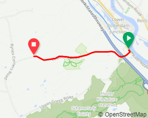 |
There are a lot of climbs in this Route 5/5S corridor, but this is the biggest.
The Strava Segment
reports 945 feet over 2.08 miles, but the full climb is 1053 feet when you start from route 5.
There is a maximum grade of 11.6%. There are various parking locations along the Erie Canalway bike path
but the below two are the closest.
View Map: Parking: |
| Climb-Pinnacle Road (3.73 miles) | |
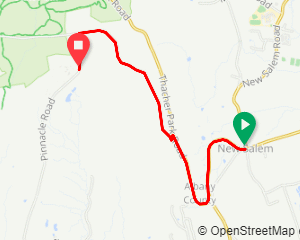 |
Pinnacle Road is where all of the local TV transmitters are located, in case you use a TV antenna.
The Strava Segment
reports 1161 feet of elevation gain over 3.73 miles. There is a maximum grade of 12.8%.
Be sure to go to the top of Pinnacle road so it counts! At the end of the segment,
be sure to stop and turn around to see the narrow view.
For a much better view, head over to the Thacher Park
scenic overlook
as it's only a few miles out of the way.
If you are interested in another nearby climb, check out Cass Road (below)
View Map: |
| Climb/Scenic-Thacher Park (7.6 miles) ? | |
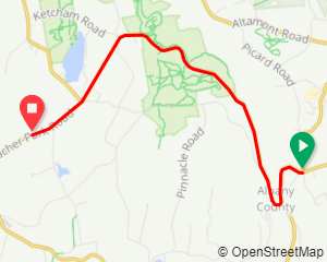 |
There can be a lot of tourist traffic on this road, so descending might be a little safer than ascending.
Look at the Pinnacle Climb (above)...that climb is safer but harder.
If riding this route in either direction, be sure to stop at the
scenic overlook.
There is a maximum grade of 8.2%
View Map: |
| Climb-Cass Hill Road (3.0 miles) | |
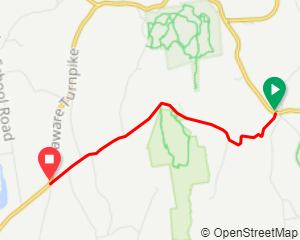 |
Although short, this is a challenging climb. The
first mile
sports an average grade of 10.1% (514 feet), maxing out at about 14%.
You think the climb is over because you start going downhill, but there are two more miles and another
310 feet of elevation gain.
Here's the full strava segment.
Cass is not too far from Thacher if wanting to do both at once.
View Map: |
| Climb-Prospect Mountain (Lake George) (5.0 miles) ? f | |
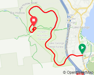 |
The author is unfamiliar with this climb, but it is a seasonal road and there is a small fee for bicycles
to enter.
The Strava Segment
reports 1482 feet of elevation gain over 5 miles.
There is a maximum grade of 12.5%
View Map: |
| Climb/Descent-Lake Desolation (3.73 miles) | |
 |
The Strava Segment
reports 989 feet of elevation gain over 4.5 miles. There is a maximum grade of 12.5%.
If you happen to glance down the power lines at the right point on the ride up,
you might see a very narrow view.
At the top, there's a lake just a few feet from the road, but no scenic overlook.
If you continue for another 2 miles after the segment, you'll find another 200 feet of
elevation gain before reaching a dirt road.
Be safe on the descent! It can be fast.
View Map: Parking: |
| Climb-Mount Greylock (from the North) (9.1 miles) | |
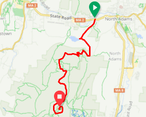 |
This might be a littler further out of the Albany area, but it's a nice climb.
The Strava Segment reports 2806 feet of climbing over 9.24 miles.
There are a few ways up to the summit from the north, but this is the way I went.
Another route to the top is
from the south (Strava Segment) which is a littler easier.
Optionally combine both of these routes and the Ashuwillticook Rail Trail to help complete the route.
View Map: |
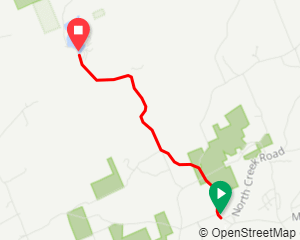
| Climb-Mount McGregor (2 miles) ? | |
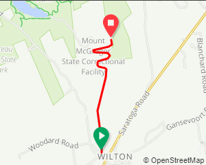 |
About 675 feet of climbing over 2 miles. There is a maximum grade of 10.6%
Verify the hours of the facility before visiting.
Although the grounds are open for free, there is a gate part of the way up the hill that may be closed.
Mt McGregor has a cabin which Ulysses S. Grant lived at for a few weeks.
Also at the top is a former
Sanitorium/Correctional facility.
At the top there is a scenic overlook, but you need to go down a narrow paved path, which cannot be
navigated with walkers also on the path; it might be difficult for some to clip in at the bottom before
starting back up.
View Map: |
| Scenic-Saratoga Lake (7.4 miles) | |
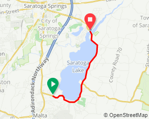 |
Frequent views of the lake. The road is narrow so be sure to pick a safe time.
View Map: |
| Scenic-Stillwater to Schuylerville (30.0 miles) | |
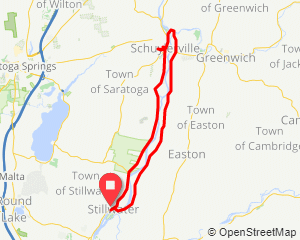 |
This route has a few nice views of the Hudson river, crossing on a footbridge into Hudson Crossing
Park then the Champlain canal (lock C-5), a short hill to the Saratoga monument, then back on a flat route
the other side of the Hudson.
Maybe add a detour into the Saratoga Battlefield.
View Map: |
| Scenic-Stillwater to Bennington VT (59.7 miles) | |
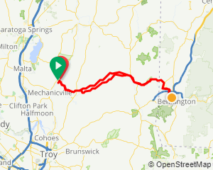 |
This route has views of the Hoosic river, numerous covered bridges, and a short climb to the
Bennington monument. There is a 1/2 mile section of dirt road on the way to Vermont, but the rest is paved.
Verify hours of the canal lock before planning to stop there.
View Map: |